


These exercises are suitable for pupils in primary as well as secondary levels and they aim to improve one’s map reading skills.
Map reading skills include understanding and perceiving a map: comparing real life three dimensional terrains to two dimensional maps. Map reading skills are needed for example in orienteering and the orienteering skill is one of the core elements of moving safely outdoors.
Orienteering means finding the targets marked on the map from the terrain and moving between the targets systematically, for example finding a route that is fast and easy to walk. Map, compass, GPS, stars, sextant, guide signs, radio signals, known landmarks and oral instructions can be used while orienteering. Nowadays electronic maps, like Google Maps, are popular tools when navigating from place to place.
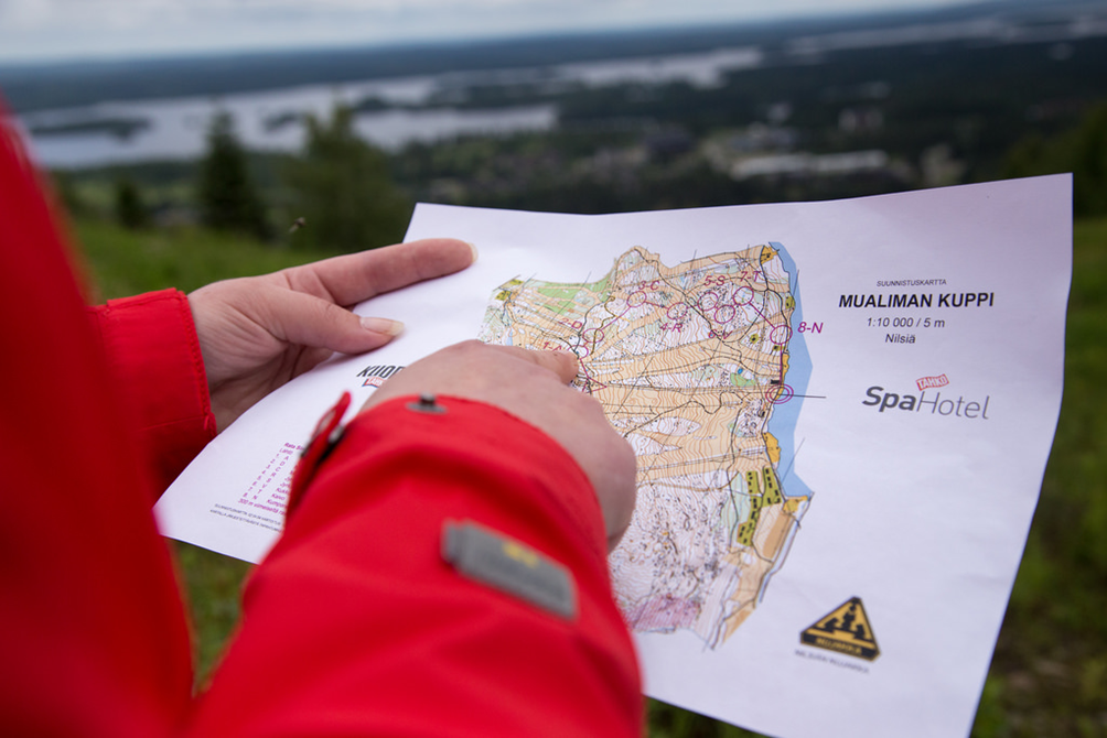
Orienteering requires many basic map reading skills like identifying map symbols, understanding scale and directions both on the map and in the terrain. Picture source: Flickr
Orienteering skills can be practiced in many ways. Traditional school orienteering uses paper maps that have targets marked on it. In addition, a compass may be used. Modern smart phones have changed every day orienteering. More and more often orienteering is done with the help of electronic maps and GPS (Global Positioning System) instead of paper maps.
Electronic devices have gotten more powerful and more common and at the same time free knowledge has increased and now consumers have multiple options of web pages, programs and applications that can be used in orienteering.
For example, in Geocaching electronic devices GPS is used to find geocaches located in specific coordinate points. Written instructions or hints may also be used to help find the cache. A cache can be big or small, they come in different shapes and they can hold in different treasures. Coordinates are given for each cache and they may be followed by written hints. Written part may explain where the cache is located, for example a certain distance from the given coordinates or it might be a puzzle.
Geocaching – modern treasure hunting
Geocaching is a modern way of searching for treasures in the surrounding nature. Geocaching combines the joy of learning and discovering and at the same time students get to exercise. Geocaching also makes one see the surroundings in a new light.
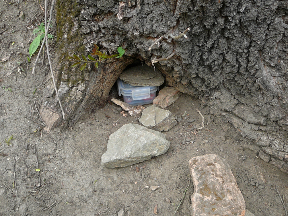
All the geocaches need to be weather proofed so that they can be hidden in the nature. Picture source: Wikimedia
You will need: Sufficient amount of smartphones or tablets, which have internet connection, GPS and for example Google Maps, a paper and a pen or an electronic platform for notes as well as coordinates and possible extra clues.
Preparations: Teacher prepares geocaches by selecting containers and filling them with “treasures”, hides them in the nature and takes down the exact coordinates of each cache. Every geocache container must be weather proofed, for example a plastic box or a minigrip bag. The protective box must contain something for the students to take with them or have a paper in it for the students to write their names on. Geocaches can also have tasks in them; one task per cache or for example one word or letter per cache, which makes up a word or a sentence after all the geocaches have been collected. Teacher can give the students either just the coordinates of each geocache or coordinates with written instructions. For example: “The geocache is located about 10 meters east-north from the given coordinates” or “the geocache is located by the trunk of a birch”. This way students can practice various skills and knowledge of chosen school subject.
Students can also participate in the preparation work. Each student, pair or group of students makes one or more geocaches: selects containers and treasures, hides them in the nature and takes down coordinates (and writes the clues). After preparing their caches, students present them to the teacher who shares all the caches for the entire school class.
Task: Students find all the geocaches in pairs or groups, take the treasures with them or write their names on the paper found in the cache, do the tasks or write down the letter or a word and form a word or a sentence.
More information:
https://www.geocaching.com/play
PaikkaOppi in orienteering
PaikkaOppi in traditional orienteering
Teacher or students can use PaikkaOppi web map to create a map of a specific area with features of their choice. The orienteering route or points can be marked on the map online and the map can be shared to the students online either as a picture or a workspace or the map can be printed. The printed map can be laminated and the orienteering points can be added afterwards with a marker, this way the same map can be used many times with different points.
Photography orienteering
Photography orienteering includes a map and a set of pictures. In this type of orienteering the map has a set of marked points, a route or an area and several photographs. The photographs are taken from the points, route or area marked on the map. The idea is for the students to find the right places marked on the map and the exact location from where the picture was taken. Teacher can also add different small tasks to each point, for example “recognize the plant next to where the photography was taken”, “name the building located east from where the picture was taken” or “do ten pushups”.
Various school subjects can be integrated into orienteering by creating different tasks. Photography orienteering can also be done with a theme: landforms, statues, plants, traffic safety, or different kinds of observation tasks like “describe the sounds in this point”.
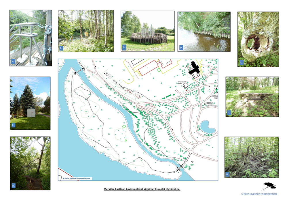
The maps for photography orienteering can, for example, look like this. Picture source: https://peda.net/pori/ops-2016/tukimateriaalit/o/kjvk/kompostointipuisto
Preparations: Teacher makes a map with points, photographs and possible extra tasks and shares them to the students online or in paper. The students can also participate in the making process of a photography orienteering map.
Task: Students find the points and photographs marked on the map and answer to the extra tasks.
Tehtävämallin kehittäminen maantieteen ja biologian opettaja Marianna Kuusela